REGINA - UPDATE: Severe thunderstorm warnings are now in place for three areas of Saskatchewan.
At 3:57 p.m. CST, Environment Canada reported they were tracking a severe thunderstorm capable of producing very strong wind gusts, up to toonie size hail and heavy rain. This thunderstorm is east if Glenavon and is moving east at 50 km/h
At 3:53 p.m. CST, Environment Canada was tracking a severe thunderstorm capable of producing very strong wind gusts, toonie to ping pong ball size hail and heavy rain.This thunderstorm is south of Lampman and is moving east at 50 km/h and the R.M. of Benson was impacted.
As well, at 3:50 p.m. CST, Environment Canada reported a severe thunderstorm capable of producing very strong wind gusts, up to toonie size hail and heavy rain.This storm is east of Cando and is moving east at 50 km/h, and impacted the R.M. of Battle River.
Much of the southern portion of the province remains under a Severe Thunderstorm Watch, with an area of eastern Saskatchewan from the Yorkton area down to highway 1 under a tornado watch. Continue to follow Sask Today for further updates on the weather situation.
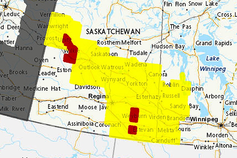
EARLIER STORY: Environment Canada has placed much of central and southeastern Saskatchewan under a severe thunderstorm watch.
The watch extends from the Alberta border into western Manitoba and includes most of central and southern Saskatchewan excepting the southwest. Included in the watch area are cities Saskatoon, Regina, Weyburn, Estevan and Yorkton.
According to Environment Canada: "Conditions are favourable for the development of dangerous thunderstorms that may be capable of producing damaging wind gusts, damaging hail and torrential rain. A low pressure system is moving through �鶹��Ƶern Saskatchewan which will trigger thunderstorms this afternoon. These thunderstorms will then drift into �鶹��Ƶwest Manitoba by the early evening. Some of these thunderstorms may become severe and have the potential to produce large hail up to 4 cm, strong wind gusts of 90 km/h, and heavy rain. The threat of severe thunderstorms will diminish by later this evening."
In addition to severe thunderstorms a number of R.M.s in southeastern Saskatchewan are under a tornado watch.
According to Environment Canada: "Conditions are favourable for these severe thunderstorms to produce tornadoes. Large hail up to 6 cm, wind gusts to 110 km/h, and heavy rain are also likely.
"In the event of a tornado, or if a tornado warning is issued for your area, it is recommended you take the following actions: Go indoors to a room on the lowest floor, away from outside walls and windows, such as a basement, bathroom, stairwell or interior closet. Leave mobile homes, vehicles, tents, trailers and other temporary or free-standing shelter, and move to a strong building if you can. As a last resort, lie in a low spot and protect your head from flying debris. Lightning kills and injures Canadians every year. Remember, when thunder roars, go indoors! Tornado watches are issued when atmospheric conditions are favourable for the development of thunderstorms that could produce tornadoes."


